"Terraflow GPS — Ground Positioning Service" Exact Drilling Coordinates. Delivered After Proper Analysis.
GPS is the final step. After your GPR report is reviewed and your operational priorities are understood — we deliver the exact coordinates your contractor drills. Nothing is left to chance.
The Ground Positioning Service is not issued at the start of a project. It is earned at the end of a proper process.
First — your land is analysed via satellite.
Second — your GPR report is delivered.
Third — we discuss your operational priorities together.
Then — and only then — your final GPS drilling coordinates are confirmed and delivered.
No GPR. No GPS. The sequence is the science.
GPS Delivers:
✅ Final optimised drilling point coordinates — latitude and longitude
✅ Depth target recommendation per drilling point
✅ Multi-well layout for large or phased projects
✅ Technical discussion with Terraflow team included
✅ Contractor-ready drilling plan — hand directly to your team
✅ Supported by Aquafuture Solutions, S.L., Barcelona, Spain
WHO NEEDS GPS
GPS is the logical next step after GPR for:
🏗️ Real Estate Developers — phased drilling across large parcels, priority sequencing before contractor mobilisation
🏭 Industrial & Manufacturing — institutional-grade drilling plan, zero tolerance for dry wells
🌾 Agriculture & Agribusiness — multi-well irrigation layout, extraction rates matched to crop demand
🏛️ Government & Infrastructure — full documentation, operationally prioritised, audit-ready
🏨 Hospitality & Residential — single precision well, exact coordinate, no wasted mobilisation cost
🇮🇳 Real Terraflow GPS — Telangana, India
Nizamabad District | India's First Terraflow Ground Positioning Service
Location: Laxmapur Village, Chandur Mandal, Nizamabad District, Telangana Commissioned by: Terraflow Solutions
Produced by: Aquafuture Solutions, S.L., Barcelona, Spain
Following delivery of the GPR report for this Telangana land parcel, the client required final drilling coordinates before contractor mobilisation. The land sits in hard rock terrain — precision positioning was critical to avoid a costly dry well.
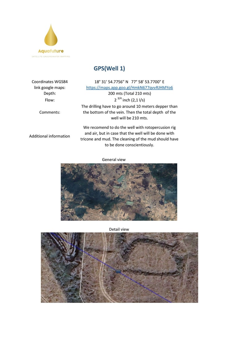
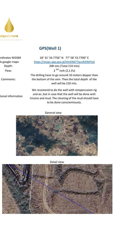
📍 Exact drilling coordinates — WGS84 precision point, linked directly to Google Maps for contractor navigation
📏 Depth target: 200 metres to vein — total well depth 210 metres (drilling 10 metres below the vein base, as per Aquafuture protocol)
💧 Confirmed flow: 2¾ inch per well (2.1 litres/second)
🔧 Drilling specification: Rotopercussion rig with air recommended — mud drilling protocol provided as secondary option with mud cleaning requirements specified
🗺️ Satellite overlay maps: General and detail view provided — exact well position marked on satellite imagery for unambiguous contractor handover
Contractor received a single document — exact location, exact depth, exact flow expectation, and drilling method guidance. No ambiguity. No interpretation required. Ready to mobilise from day one.
This GPS report was issued as part of India's first complete Terraflow GPR + GPS project cycle.
Frequently asked questions
1. What does GPS stand for at Terraflow? Ground Positioning Service — not a satellite navigation system. It is Terraflow's final precision output: optimised drilling coordinates delivered after technical discussion and operational prioritization.
3. How long after GPR is GPS delivered? GPS is delivered after your technical discussion with the Terraflow team. We aim to conduct that discussion within 48 hours of your GPR delivery — your final coordinates follow shortly after.
2. Do I need GPR before GPS? Yes — always. GPS is only issued after a completed GPR analysis. We do not issue drilling coordinates without first understanding the full hydrogeological picture of your land. No GPR. No GPS.
5. Is the technical discussion remote? Yes — 100% remote. Phone, WhatsApp, or video call. No site visit required at any stage of the Terraflow process.
6. What exactly does my contractor receive? Exact GPS coordinates, depth targets per drilling point, and operational sequencing notes — everything needed to mobilise and begin drilling immediately.
7. Can I get GPS using a survey from another company? No. Terraflow GPS is only issued based on Aquafuture satellite analysis. We cannot build on or validate third-party survey data.
8. Which states in India are covered? All 28 states and 8 Union Territories — 100% remotely. No site visit required anywhere in India.
4. Can GPS cover multiple wells? Yes. For large parcels and phased projects, GPS delivers a complete priority-sequenced multi-well drilling plan — not just a single coordinate point.
