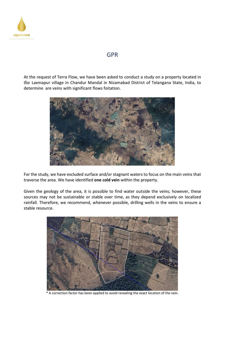
Terraflow GPR — Ground Property Report Not A Device. Not A Field Survey. A Satellite Intelligence Report.
The Ground Property Report (GPR) is TerraFlow's core satellite-based subsurface assessment for India. Before committing to borewell investment, GPR identifies the precise location, depth, and yield potential of rechargeable groundwater veins using remote AI-driven analysis — no site visits, no guesswork. Delivered within 48 hours of coordinate submission. GPR supports IGBC Net Zero Water certification compliance under NBC 2016 Clause 4.1.2, making it essential for green building projects and real estate developments across India.
This Is Not Your Traditional GPR
Traditional GPR — Ground Penetrating Radar —
is a physical machine. It requires technicians to walk your entire land parcel, dragging equipment across every metre of your property. It takes days or weeks on site. It is expensive. It is intrusive. And critically — it identifies surface-level anomalies, not deep recharging groundwater veins.
Terraflow's GPR is built on an entirely different philosophy.
Our Ground Property Report is a comprehensive satellite intelligence document — analysed remotely from space using Google Earth Engine, Sentinel — processed through Aquafuture's proprietary AI framework. No equipment. No technicians. No site visit. Ever.
What Your GPR Report Contains
✅ Satellite aerial overview of your exact land parcel High-resolution satellite image of your property boundaries and surrounding terrain
✅ Groundwater vein identification Cold recharging veins identified and mapped within your property — surface and stagnant waters excluded
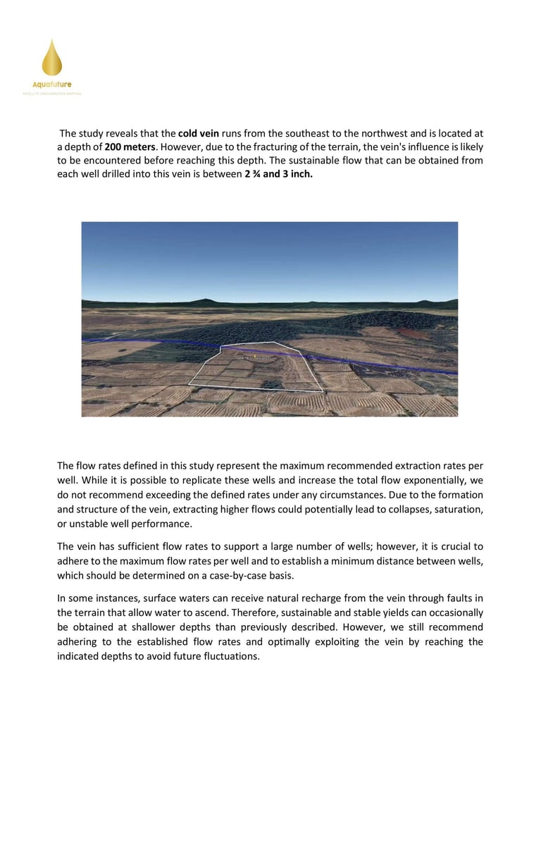
✅ Vein direction and flow path Exact direction the vein runs across your land — Southeast to Northwest in the Telangana case study
✅ Depth analysis Target depth to the vein identified — with notes on fracture zones where water may be encountered earlier
✅ Sustainable flow rate per well Maximum recommended extraction rate per well — e.g. 2¾ to 3 inch per well in Nizamabad
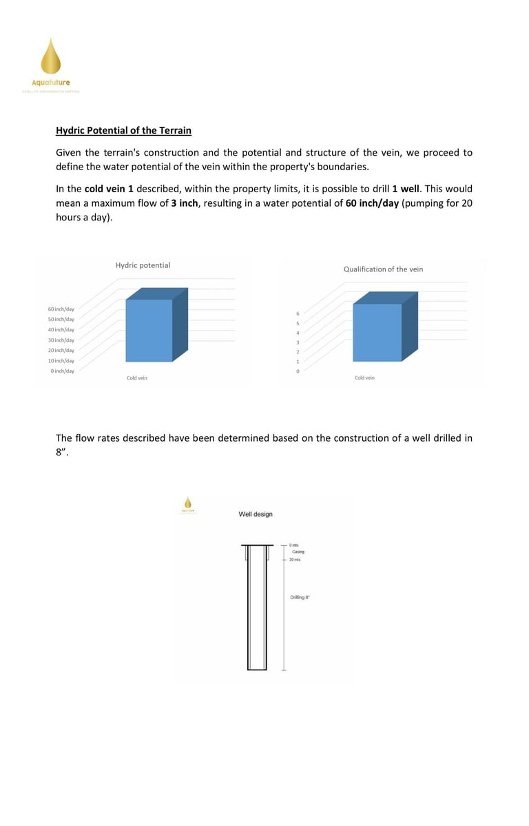
✅ Hydric potential assessment Total daily water potential within your property boundaries — e.g. 60 inch/day pumping 20 hours
✅ Vein qualification score Stability and recharge rating of each identified vein
✅ Advanced structural and geomorphological analysis Six subsurface analysis maps showing terrain construction, vein structure and groundwater hotspots
✅ 3D terrain model Visual depth profile showing vein orientation across your land
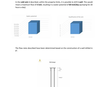
✅ Well design specification Drilling diameter, casing depth and construction parameters — e.g. 8-inch diameter drilling
✅ Maximum extraction rate guidance Clear limits on flow rates per well to prevent collapse, saturation or unstable performance
✅ Signed report — Technical Report of Aquafuture Solutions, S.L., Barcelona, Spain
🇮🇳 Real Terraflow GPR — Telangana, India Nizamabad District | India's First Terraflow Ground Property Report
Location: Laxmapur Village, Chandur Mandal, Nizamabad District, Telangana, India Commissioned by: Terraflow Solutions Produced by: Aquafuture Solutions, S.L.
The Challenge: A land parcel in Telangana's hard rock terrain required groundwater assessment before any drilling investment. No traditional survey could provide the depth, accuracy, or speed required.
What Terraflow GPR Found: Satellite analysis identified one cold recharging groundwater vein traversing the property. All surface and stagnant water sources were excluded — only the stable, recharging vein was mapped and documented.
Report Findings:
🌊 Vein Type: Cold recharging groundwater vein
🧭 Direction: Southeast to Northwest
📏 Depth: 200 metres
💧 Sustainable Flow: 2¾ to 3 inch per well
📊 Daily Hydric Potential: 60 inch/day (20 hours pumping)
🎯 Wells Recommended: 1 precision-positioned well
🔧 Specification: 8-inch diameter drilling
The Outcome: Client received India's first Terraflow Ground Property Report — complete drilling intelligence with zero site visit, zero disruption, zero guesswork. Ready to drill with full confidence from day one.
Every Ground Property Report Covers Up To 50 Hectares
Each Terraflow GPR analyses a land parcel of up to 50 hectares — delivering complete subsurface groundwater intelligence across every metre of that footprint with maximum precision and accuracy.
50 hectares is equivalent to:
🌾 A large agricultural farm
🏭 A mid-to-large industrial facility
🏗️ A township or real estate development of 100+ acres
🏛️ A government water project zone
Larger Projects? No Problem.
For land parcels exceeding 50 hectares — industrial parks, SEZ developments, district-level government projects, or large agricultural cooperatives — we deliver multiple coordinated GPRs covering your entire footprint systematically.
Each report zone is analysed at maximum resolution, ensuring no groundwater vein is missed across your full project area. Larger projects receive:
✅ Zoned coverage maps showing each GPR area
✅ Consolidated findings across all zones
✅ Unified drilling strategy for the full project footprint
✅ Priority zone identification — highest yield areas first
Why India Needs Terraflow GPR — Not Traditional Surveys
Traditional ground surveys in India have not kept pace with the country's groundwater crisis. Methods designed for smaller, simpler parcels are being applied to large agricultural holdings, industrial facilities, and township developments — with predictable results.
Terraflow's Ground Property Report was designed specifically to fill this gap. It scales to any land size. It works in any Indian geology — hard rock Telangana, alluvial Punjab, basalt Maharashtra, granite Karnataka. It requires nothing from you except your land coordinates.
For the first time in India — groundwater intelligence is as fast, as remote, and as institutional-grade as the projects that depend on it.
One report. Delivered in 48 hours. Signed Technical Report from Spain's leading satellite groundwater organisation.
That is the Terraflow Ground Property Report.
Frequently asked questions
Q: What does GPR stand for at Terraflow Solutions?
A: GPR stands for Ground Property Report — a proprietary satellite-based groundwater intelligence report delivered by Terraflow Solutions and produced by Aquafuture Solutions, S.L. It is completely different from traditional Ground Penetrating Radar equipment.
Q: How large an area does one GPR cover?
A: Each Ground Property Report covers up to 50 hectares — equivalent to a large farm, industrial facility, or real estate development. For larger projects we deliver multiple coordinated reports covering your full footprint.
Q: Do you need to visit my land to produce a GPR?
A: Never. Terraflow's Ground Property Report is produced entirely via satellite — 100% remotely. We only need your land coordinates. No technicians, no equipment, no site visit — ever.
Q: How long does a Terraflow GPR take?
A: Your complete Ground Property Report is delivered within 48 hours of receiving your land coordinates.
Q: Which states in India do you cover?
A: We cover all 28 states and 8 union territories across India — including Telangana, Rajasthan, Maharashtra, Tamil Nadu, Gujarat, Karnataka, Andhra Pradesh, Punjab, Uttar Pradesh, Madhya Pradesh, Odisha, West Bengal, and beyond.
Q: How accurate is the Terraflow GPR?
A: Aquafuture's satellite groundwater methodology achieves a +90% success rate — validated across 14+ countries and 1,200+ completed wells globally including projects for Tesla GigaFactory, Heineken, and the Dubai Crown Prince Office.
Q: What is the difference between a GPR and a traditional groundwater survey?
A: Traditional surveys require physical field equipment, technicians on your land, and weeks of work — Traditional surveys report variable success rates — Terraflow's methodology has been validated at +90% across 1,200+ completed wells globally, covering up to 50 hectares per report, with exact drilling coordinates and full sustainability assessment.
Q: Can a GPR be used for agricultural land?
A: Yes. The Terraflow GPR is ideal for agricultural land — farms, irrigation projects, sugarcane cooperatives, and agribusiness holdings across India. Our first India GPR was commissioned for agricultural land in Nizamabad District, Telangana.
Q: What is the cost of a Terraflow Ground Property Report?
A: Contact us directly for pricing — every project is assessed individually based on land size, location, and project requirements. We offer a free preliminary assessment before any commitment.
