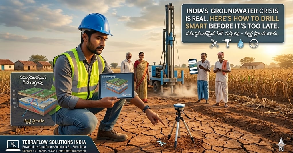
India's Groundwater Crisis Is Real. Here's How to Drill Smart Before It's Too Late.
India is sitting on a water emergency that most people won't feel until it arrives without warning. The numbers from CGWB and national water planning bodies are unambiguous: India's per capita freshwater availability stands at 1,118 cubic metres per year — already below the internationally defined water stress threshold of 1,700 cubic metres. In cities like Hyderabad, the gap between supply and demand has crossed 20%. By 2030, national water demand is projected to be twice the available supply. The economic consequence: a 6% GDP contraction risk by 2050 if groundwater depletion continues at current rates. This is not a distant policy problem. It is a present-day drilling problem — and the way India drills borewells today is making it significantly worse.
GROUNDWATER INTELLIGENCE
The Drilling Problem Nobody Talks About
Every year, hundreds of thousands of borewells are drilled across India. A significant proportion of them — by conservative estimates from CGWB data — fail to yield usable water or are abandoned within months of completion.
Each failed borewell represents three overlapping losses. The direct financial cost: ₹3–8 lakh per failed hole, depending on depth and casing. The environmental cost: a penetrated aquifer, a destabilised water table, and in many cases a collapsed casing that contaminates the local geology. And the opportunity cost: the time, the project delay, the erosion of investor confidence.
The reason most borewells fail is not that the water isn't there. It's that the drill goes in the wrong place, at the wrong angle, targeting the wrong geological layer — because no pre-drill intelligence was used.
In hard rock terrain — which covers more than 65% of India — groundwater does not sit in convenient underground pools. It concentrates in fracture zones, faults, and weathered channels that are highly localised. A borewell 30 metres away from the correct position may miss a productive fracture entirely. And once you've drilled, the money is gone.
What Satellite-Based Intelligence Actually Resolves
The crisis in groundwater management is partly a data crisis. Regional monitoring tells us the system is under pressure. It does not tell us, at any specific location, whether a productive and rechargeable groundwater source exists — and where precisely to access it.
This is the gap that satellite-based remote analytical intelligence addresses.
TerraFlow Solutions India provides satellite-based groundwater risk assessment, including local geological conditions risk assessment, powered by Aquafuture's remote analytical intelligence — integrating AI-driven modelling, satellite imagery, geological database archives, and structural and geomorphological analysis. No site visits. Pure data intelligence.
The output is a Ground Property Report (GPR): a decision-grade document that resolves the five-layer geological profile at your specific coordinates, identifies fracture zones and vein orientation, and assigns a confidence level to groundwater presence and yield potential — all within 48 hours of receiving your site coordinates.
This is not a live map. It is pre-drill intelligence built on multi-source satellite data — Sentinel, Copernicus, LiDAR integration, and CGWB geological archives — processed through AI modelling to produce site-specific answers.
The Rechargeable Vein Distinction
Not all groundwater is equal. One of the most important distinctions GPR analysis makes is between static water — trapped in geological formations, finite and non-replenishing — and rechargeable veins, which are seasonally replenished fracture channels connected to regional recharge pathways.
In depletion-stressed regions, drilling into a static body gives you water once. Drilling into a rechargeable vein gives you a sustainable source that aligns with India's long-term water security goals.
GPR analysis specifically targets rechargeable secondary fracture zones — the layer sitting between 80 and 200 metres depth in hard rock terrain — where structural geology intersects with hydrological recharge patterns. This is the difference between solving a water problem once and solving it for the next 30 years.
Kayseri: What Depletion-Era Drilling Looks Like Without Intelligence
In Kayseri, Turkey — a region under comparable hard rock stress — a project committed two boreholes using conventional survey methods. Both failed. Total loss exceeded €5 million.
The regional geology was not poorly understood. The mistake was that no site-specific subsurface intelligence guided the drill location. After commissioning a GPR analysis, the fracture zone was precisely identified. The third borehole struck 57 cubic metres per hour at 430 metres — a pressurised, rechargeable deep source. Two failed boreholes. One GPR. An entirely different outcome.
The India parallel is exact. The scale of depletion stress makes it more urgent, not less.
IGBC and the Net Zero Water Framework
India's green building movement has begun formalising water accountability at the design stage. The IGBC Net Zero Water framework — one of four IGBC Net Zero pillars — defines a pathway to water-neutral construction through a six-step certification process.
TerraFlow sits at Step 02 of that pathway: Feasibility Studies. GPR analysis validates subsurface yield potential before borewell commitment, directly supporting NBC 2016 Clause 4.1.2, which mandates water consumption planning, and IGBC Mandatory Requirement 2 on Soil Erosion Control.
For developers building to IGBC standards, a GPR is not optional due diligence. It is the data foundation for credible water planning.
The Smart Drilling Imperative
The depletion crisis will not be solved by drilling more borewells. It will be solved by drilling fewer — and getting each one right.
That requires knowing the subsurface before the drill moves. It requires treating each borewell commitment as a data-driven decision, not a location guess.
TerraFlow Solutions India delivers that intelligence: a Ground Property Report for any site across India, in 48 hours, without a single site visit.
🇺🇳 Aligned with UN SDG 6 (Clean Water and Sanitation), SDG 13 (Climate Action), and SDG 15 (Life on Land). Every GPR supports India's national water security goals by replacing extraction guesswork with precision intelligence.
India's water can't afford bad drilling decisions. Neither can yours.
Request a Ground Property Report → terraflowsolutions.in
TerraFlow Solutions India is the Official India Partner of Aquafuture Solutions S.L., Barcelona, Spain.