The Future of Water: Eliminating Drilling Risks with Satellite Groundwater Intelligence
In an era of depleting water tables and unpredictable climate patterns, traditional "guess-and-drill" methods for finding water are no longer viable. For farmers, industrial developers, and real estate planners, a dry borewell isn't just a disappointment—it’s a massive financial loss and a setback for project timelines.
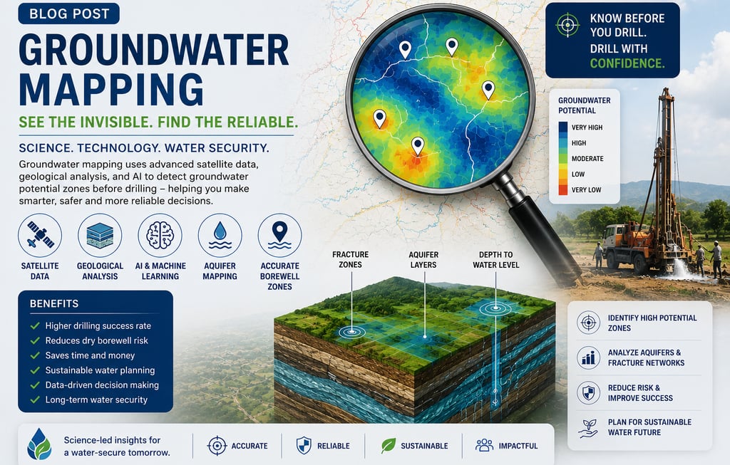
GROUNDWATER MAPPING
This is where Terraflow Solutions, in partnership with Barcelona-based Aquafuture Solutions, is changing the game. Using AI-powered satellite technology, we provide 100% remote groundwater intelligence that removes the guesswork from hydrogeology and aquifer mapping.
How Satellite Groundwater Mapping Works
Unlike traditional "diviners" or on-site geologists, our technology leverages multi-layer satellite data from sources like Google Earth Engine, Sentinel, Copernicus, Landsat, and LIDAR. This data is processed through an exclusive AI-driven engine to identify constantly recharging groundwater veins deep beneath the surface
Our Two-Step Intelligence Solution
We deliver a comprehensive subsurface picture without ever setting foot on your site:
GPR (Ground Property Report): Within 48 hours, you receive a detailed report including groundwater potential assessments, estimated depth ranges, sustainable yield ranges, and structural geological analysis.
GPS (Ground Positioning Service): Following the GPR, we provide exact, optimized drilling coordinates. This pinpoint accuracy ensures the rig hits the most productive part of the vein, maximizing flow and long-term stability
Case Study: Success Where Others Failed
Our technology has been proven in some of the most challenging terrains globally:
Kayseri, Turkey: In a region where two previous wells had failed after drilling to depths of 2,400 and 2,500 meters (a €5 million loss), our remote survey identified a successful thermal spring at just 430 meters.
India Success: In Laxmapur village, Telangana, a project struck water exactly at the depth and flow rate predicted by our GPR and GPS reports.
Why Choose Satellite Intelligence?
100% Remote: We require zero site visits—your coordinates are all we need.
High Confidence: With over 20 years of expertise and a 90%+ efficiency rate, we minimize the risk of "drilling blind".
Sustainability: We focus on identifying recharging veins to prevent overexploitation and ensure a long-term water supply.
Speed: Comprehensive intelligence reports are delivered in just 48 hours.
Ready to secure your water future? Stop wasting capital on failed borewells. Contact Terraflow Solutions today for a scientific groundwater risk assessment.
Borewell Audit & Risk Management
In addition to the GPR and GPS services for new drilling, Terraflow and Aquafuture provide a specialized Borewell Audit & Risk Management service designed to optimize and protect existing groundwater assets. This service transitions from reactive drilling to proactive, long-term groundwater governance.
Why Conduct a Borewell Audit?
Many industrial and agricultural users face declining yields or seasonal water shortages without knowing the cause. The audit process provides clarity on several critical fronts:
Production Optimization: Identifies whether a current well is meeting its full potential based on the recharge capacity of the underlying aquifer.
Sustainability Mapping: Pinpoints the exact recharge sources (veins) sustaining the well to plan for long-term extraction without overexploitation.
Risk Mitigation: Assesses seasonality risks and identifies potential depletion or saturation threats before they lead to pump failure or dry holes.
Well Rehabilitation: Explores next-generation technologies that can recover at least 20% of lost flow in existing boreholes.
The Audit Process & Deliverables
The audit is conducted 100% remotely using the same multi-layer satellite intelligence used for new surveys. Key components include:
Aquifer Potential Analysis: Accurate data on the extraction aquifer’s real recharge potential to avoid costly mismanagement.
Annual Risk Reviews: Recommended monitoring of veins and recharge flow rates to identify significant year-on-year variations.
Corrective Action Planning: If variations are found, the audit may recommend production adjustments, cleaning via sonic pulses, or the exploration of alternative extraction zones.
Compliance & Reporting: Provides a "Groundwater Due Diligence" or annual sustainability report that can be used for regulatory compliance or investor relations.
Who is it for?
Industrial Facilities: Factories, pharma units, and textile plants requiring high-volume, stable water supplies.
Real Estate Developers: For townships and residential projects needing to ensure long-term water security for residents.
Commercial Agriculture: Large-scale farms looking to stabilize irrigation during dry seasons.
→ Request your Ground Property Report at terraflowsolutions.in
→ WhatsApp direct: +91 88855 74433
TerraFlow Solutions India
Official India Partner — Aquafuture Solutions, S.L., Barcelona, Spain
terraflowsolutions.in | +91 88855 74433